For newcomers

At the bottom of each post there is the word "comments". If you click on it you will see comments made by followers, and if you follow the instructions you may also comment and I always welcome that. I have found many people overlook this part of the blog which is often more interesting than the original post!

My blog nick-name is SIR HUGH. I'm not from the aristocracy - my middle name is Hugh which relates to the list of 282 hills in Scotland compiled by Sir Hugh Munro in 1891. I climbed my last one (Sgurr Mor) on 28th June 2009

****************************

Friday, 16 May 2025

Galgate,Glasson Canal and Lancaster bomber

 Thursday 15th May 2025

I seem to have adopted the idea of looking for remotely located churches on the map. I wanted a quick sortie not far from home.

We are in the middle of a prolonged period of hot weather with lack of rain for farmers and general water supply making the news.  For me it is all delight. No mud, shirt sleeve walking, and shorts.

Tarmac out of Galgate quickly lead to enjoyable country walking on new paths for me until I finished up with the final stretch back to Galgate on the familiar Glasson canal tow path.

The church was visited but unfortunately locked. I gleaned some history from the Internet:

"The Parish was founded in 1785 with Fr. James Foster as Parish Priest. Previously the district was served by travelling priests who usually stayed with the Dalton Family at Thurnham Hall. The first named of these priests was Rev. North who lived at the end of the sixteenth century. However, the most famous was a Rev. James Swarbrick who was well known as "The Riding Priest". He was arrested in 1715 and taken to Lancaster Castle where he was condemned as a priest. A few days before he was due to be executed the old man died in prison in 1716, possibly as a result of torture. We still have the little chalice he carried on his travels." ------  Happy days!
My italics.

From Wikipedia regarding the extant church building:

Fr. Foster’s successor, Fr. Thomas Crowe, oversaw plans for a new church. Financial support came from Miss Elizabeth Dalton, who covered most of the costs. The foundation stone was laid on March 18, 1847, and the church was consecrated on August 29, 1848. Three bishops—Bishop Browne, Bishop Briggs, and Bishop Sharples—were present at the dedication, which included a grand procession from Thurnham Hall. The final cost of the church, including furnishings, was £5,000.

Walking out of Galgate this seemed to be quite out of place, just parked up. I reckon some farmers use their tractors as personal transport from time to time?

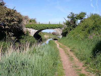
Ellel Hall Bridge. Lancaster Canal

Transcript:
"Ellersley Farm Museum.
Ferguson A 20
Serial No. 31363
Bought new in 1948 by Sellery Farm"

See below

Oddly pitifully stored and neglected with the faded sign above. So sad. It is the same MF I made a model of. An icon in tractor development

The tractor is just behind me

 My route followed the wall in shadow, right centre

Perfect walking surface

River Condor

Here I crossed the Glasson branch of the Lancaster Canal. Great views of the Bowland Hills from the top of the bridge - Clougha Pike, Ward's Stone etc. They were evident during most of the walk


Under or over? Neither seemed a good idea. I climbed the gate

Looking towards Glasson on the Glasson canal

Thornham Hall. Event venue and holiday cottages. Quite pretty.

The target for my walk


Overflow graveyard. Regimental.

This and next from its other side. Although obviously not used I imagined the farmer was sentimentally attached and jibbed at consigning it to the scrap heap, so now it performs sentry duty at the farmyard entrance.


Looking back at Cock Hall Farm, home of the David Brown 990

Perfect pleasant picnic perch.
 I watched a pair of buzzards high up putting the Red Arrows to shame

The rest of the route followed the Glasson Canal and then back to Galgate after joining the Lancaster Canal proper


------------------------------

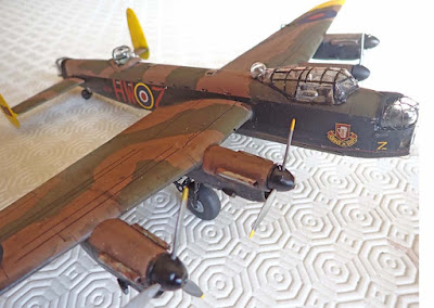
The finished 1/72 nd. scale Lancaster


Friday, 2 May 2025

Tank diorama

Thursday 2nd May 2025 

This project has been ongoing since Christmas (on and off.)

I have had to learn a new skill using foam to make the body of the barn. All those bricks are individually made from foam using my Proxon foam hot wire cutter.

The scene shows an Achilles tank somewhere in Normandy after D Day holed up in front of an old French barn. The lorry has arrived with more fuel and shells. The low ranking soldier in the rear of the lorry  is passing a shell to the tank crew, There is a fuel line from the barrel in the wagon going to the filler cap at the far end of the tank. The other tank crew are just looking at some minor problem with the lorry's engine.

PLEASE CLICK TO ENLARGE


Thursday, 24 April 2025

Helton Askham circular

Wednesday 23rd. April 2025 

Continuation of my exploration of the northern foothills and minor dales  of High Street.

Car parking had been identified using Google Earth. A steep cul-de-sac road leads from Helton which in less than quarter of a mile arrives at a cattle grid and then unfenced road where parking is possible. My walking route continued on that road, but I knew that the steep climb from Helton may be my nemesis at the end of a fairly strenuous six miler, something that wouldn't have even entered my mind before I was afflicted with my breathing problem.

The road continued climbing until I could branch off on a track on now extensive undulating moorland stretching away to the northern slopes of High Street. Here there is a network of well defined tacks and paths to connect with High Street and Pooley Bridge and Heughsacr Hill. I realized that this is a fairly popular walking area and I met quite a few others on and off. The walking on perfect turf and tracks was the very best of Lakeland terrain. At the northern end of the moorland the land drops away down to Ullswater and I was rewarded by a surprise view down to our second largest lake with Blencathra (Saddleback) in a haze in the background. My route skirted Heughscar Hill which I have ascended in the past, and it was quite steep climb from the moorland to skirt high up underneath Heugh Scar. My affliction really rules out climbing the major peaks of the Lakes but I still strive to get on high if possible and today's route enabled that by having a relatively  high starting point  at about 260m. Long may I continue to find such ways and means to have the pleasure of being on high.

Descent and a stretch of road walking was pleasant enough to arrive at the pretty village of Askham. Here a footpath cuts out some of the road walking back down to Helton. A one point a lamb had its head stuck through that six inch square fencing wire. There was no way it was going to escape and I managed to extract it, but ripping my cherished Berghaus Hollowfill jacket that has accompanied me on many trips including my Land's End John 'o Groats walk. 

I had been having some unreasonable foreboding about climbing that steep little stretch back to the car, I took it steadily and arrived back at the start in good form. That was  an exceptionally good walk . I have one more planned not far way which I think will exhaust possibilities in that area.


Worth clicking photos to enlarge.

Just above the cattle grid, and looking to the start of my walking. It was uphill for a while until I was able to branch off onto the moorland


Off onto perfect turf and tracks


It is difficult to envisage what went on so long ago at these stone circles. We can only glean a bit from the imaginations of some of our more fanciful archaeologists. 

Approaching the surprise view of Ullswaster


Heugh Scar. Quite a climb (for me) to get up there but well worth it

Looks a bit like a Heaton Cooper painting?

Not sure what this is. I guess something to do with water supply. It is not likely to be one of those nuclear bunkers - digging anything out into the underlying rock here would be above and beyond. Anybody know any more ?

Walking out of Askham to pick up the path back to Helton. 1696 is going back a long wsy. This building had various patched up doorways and windows, but good to see that these and the inscription stone have been preserved in the recent restoration.

Looking back down to Helton village from halfway up the short steep ascent back to my car.

Clockwise from cattle grid just south west of Helton


Wednesday, 9 April 2025

Low Kop from Cawdale

 Tuesday 8th April 2025

My previous post covered my discovery of, and delight in Cawdale. So much so that I had a compulsive desire to go beyond that tempting peek round the corner looking up to the head of the dale. From the previous visit I knew I could park at the end of the Tarmac and walk directly into Cawdale, but could I climb out of the end of the dale to summit Low Kop and return by The Hause making for a desirable circular? That would be only just over four miles, but the ascent to Low Kop would be a challenge for my breathlessness affliction. There is a very rude quip originating from a medieval version about "...winning a fair lady" I can't repeat my version here but it borrows the same starting words, "faint heart never..."

We are in thé midst of an exceptional weather window and blue skies and warm sunshine prevailed.  One has to be ruthless and dismiss other pressing matters: putting on the washing, mowing the lawn grass, attending to the recycling et al, and seize the opportunity.

I launched into the now familiar march up Cawdale, I was now thinking of this as my own private and secret dale. All was tranquil and a tonic to the soul. After an hour or so I was back at my last furthest point.  From there the gorge steepened and the stream down below was more active with mini waterfalls gurgling, glinting and splashing as it tackles the steeper drops. At the head of the dale there are remains of old sheep enclosures. Here I sat and soaked up the atmosphere and supped a coffee from my flask. That flask is a good old friend of over twenty years. It visited  most of my Munros and cheered me on  countless other day outings. I was perhaps procrastinating about the now steep ascent to Low Kop, but in a pleasant kind of way.

That climb was particularly demanding in view of my, breathlessness but the medics have encouraged me to continue with my walking and I still have the urge to take on more serious fell walking with its remoteness and challenge rather than plod round the edge of farmers' fields. There was no path but the tussocky grass terrain made for reasonably easy going, but with the steepness I was stopping to catch breath every twenty steps or so. I took a long time.

Eventually the slope eased leading to a more gentle approach to the summit. I had looked st Hill Bagging and noted that Low Kop is a "Birkett," not that I am ticking them off and I have no recollection of other hills I have climbed having that distinction. The summit was marked by a white quartz rock nestling in the grass about the size of a teapot.

The three kilometres return followed a wide grassy path with an uninterrupted descent of  330m, as much as one would likely encounter on a good Munro. Not far from that track a wooden sign post lay flat on the ground, thus eliminating its intended purpose to direct, but informing me that one of the two path options ahead was a diversion to "avoid a deep ford." My iPhone Memory Map has both OS 1:25 and 1:50 but I was using the 1:50 and the ford was not marked and I hadn't thought to  look at the 1:25 where it is clearly marked. So It was fifty-fifty. I chose the wrong one. However the stream was easily crossed a few metres upstream from the ford and I was back at my car looking up at that long distinctive descent. It had taken me five hours to cover four miles. My achievement of climbing a reasonably respectable Lakeland  summit with according to Memory Map, 930 ft. of ascent, in no way indicates that my physical ability has improved, but I was well heartened to have done so and thankful that it is till possible at my advanced years. What a good day.


Note the long line of Pennines on the horizon. That is only a small part of the exceptional length of our Pennine hills seen from many parts of this and my previous walk here. 

Welcoming committee? They were quite docile

Path goes past end of second white cottage, then skirts hillside above to enter and descend into Cawdale at the top of the stand of trees top left of photo

Looking back down to that second white cottage

Cawdale. My route and track skirt below the lefthand trees round the corner of the spur

Looking back down the dale. My entry into the dale is from the top of the distant trees

Cawdale Beck. Now more lively in the steeper gorge


Old sheep folds. Here I rested with a coffee before ascending steeply above out of left of photo

Looking back down to the sheepfolds. By no means anywhere near the top of my climb!

The modest but proud marker of Low Kop summit

A small section of the long descent of The Hause. The track provided excellent walking

The non-doing signpost

Looking back at the ford. I easily crossed the stream just to the right

Back at the car. A little weary and looking back at that long descent of the Hause.


OSZAR »